The Jacksonville Planning Commission on July 23 recommended approval for The Trails large-scale land use amendment for a less dense development than previously proposed on 2,167.51 acres in Southwest Jacksonville.
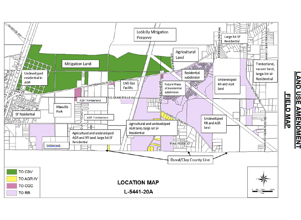
The property generally is between the Clay County line and north of Normandy Boulevard and between and U.S. 301.
The primary landowners are Diamond Timber Investments LLC, Timber Forest Trail Investments LLC and Longleaf Timber Co. Inc., along with other owners.
Originally, the landowners sought a large-scale land use amendment in 2019, through Ordinance 2019-0309, to allow up to 5,000 single-family homes and 225,100 square feet of commercial space.
An impact analysis by the city shows the land use change creates two potential development scenerios.
The first scenerio indicates up to 2,584 dwelling units and 349,134 square feet of nonresidential.
The second scenerio shows up to 2,858 dwelling units and 69,826 square feet of nonresidential.
After area residents opposed The Trails project in the rural neighborhood, the property owners withdrew the application Oct. 8 to change the land use designations from rural residential, agriculture II, agriculture III, agriculture IV and light industrial to low density residential, community/general commercial and agriculture-IV.
The proposed amendment, Ordinance 2020-0279, seeks to correct land use discrepancies, place land in conservation and allow rural residential and community/general commercial land use.
The owners submitted the revised land use amendment application March 10, with the major change from the requested low density residential to rural residential and include conservation.
The current land use breakdown of the property is:
• Rural residential: 35.81 acres
• Agriculture II: 110 acres
• Agriculture III: 1,776.65 acres
• Agriculture IV: 228.27 acres
• Light industrial: 16.78
The requested land use breakdown of the property is:
• Rural residential: 1,284.08 acres
• Community/general commercial: 22.9 acres
• Agriculture IV: 41.07 acres
• Conservation: 819.46 acres
Rural residential land use, the predominant land use, is intended to provide rural estate residential in the suburban and rural areas of the city with single-family detached housing as the main use.
Rural residential provides a lower density of residential use, which means fewer homes are sought due to larger lot requirements than previously requested.
Supporting community/general commercial uses, which allow the sales of retail goods and services, are proposed along the southside of Normandy Boulevard.
The Planning and Development Department said the proximity to Cecil Commerce Center will drive the need for housing and business needs in the area.
Steve Diebenow, a real estate, land use, zoning and government law attorney who represents landowners, said April 7 the city sponsored the application to “clean up all of the land uses throughout the region” to include private homeowners who have land uses that do not conform with the actual use.
The city included the 818.46 acres in a mitigation bank north of Normandy Boulevard to correct the land use to conservation, he said.
The application is part of the transmittal round of review. If approved through City Council, the application will be reviewed by the state and returned for the adoption review to the city with a companion rezoning application for planned unit development.